How to Find the Henry Eyring Building
Map of the Important Parts of Campus (see driving directions below)
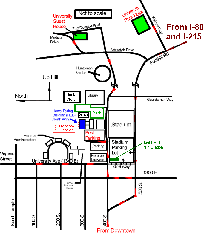
Finding the U and driving in Salt Lake City:
(if the street naming convention is confusing, read the explanation, below)
From the airport: Follow signs for downtown. Exit at 6th south (also known as 600 S) and go east (toward mountains). 600 S is a one way street, skirting the south edge of downtown. Eventually (at about 600 E), you will see signs that 600 S is about to become a two way road. At this point, you want to jog left (north) two blocks to 400 S. Continue east on 400 S. As it climbs a steep hill it will jog right (south) one block and turn into 500 S. At this point, you are at the lower left corner of my map. Follow the red arrows to the chemistry parking lot (indicated as "Best Parking"). If you are heading for the Marriot University Park Hotel, just follow 500 S as it curves south and becomes Foothill drive.
The Street Naming convention in Salt Lake City
Salt Lake is unusually easy to navigate because it is laid out as a N-S, E-W grid, with the origin of the coordinate system being a main intersection downtown. The streets mostly follow N-S, E-W grid lines and are mostly named with their coordinate. For example, the main shopping street near the University is 1300 E -- a N-S street that is 13 blocks east of the origin. Some streets, usually those that are not on grid lines, also have names. The street running just in front of the University is University Ave, which is also 1340 E (the street signs give both name and grid coordinate for streets). This street is a N-S street, 13.4 blocks east of the origin.
One slight confusion is that folks get tired of saying things like "the corner of 700 E and 900 S" and shorten as "the corner of 7th E and 9th south" Occasionally this also happens on highway signs, but all is usually clear from context.
Addresses are given as grid coordinates: For example, the Saltaire Bed and Breakfast is at 164 S, 900 E. The address indicates that this B&B is on the street named 900 E (a N-S street, 9 blocks east of the origin), 1.64 blocks south of the origin (i.e. about halfway between the streets named 100 S and 200 S) The Chemistry Building is at 315 S 1400 E, so just from the address you can tell that you need to go five blocks east and about 1.5 blocks south if you were walking from Saltaire to Chemistry.
Some of the main streets downtown have names, even though they are grid lines:
N-S Named streets:
West Temple = 100W
Main = 0 (i.e. the N-S axis of the grid system)
State St = 100 E
E-W Named streets
North Temple = 100 N
S. Temple = 0 (i.e. the E-W axis)